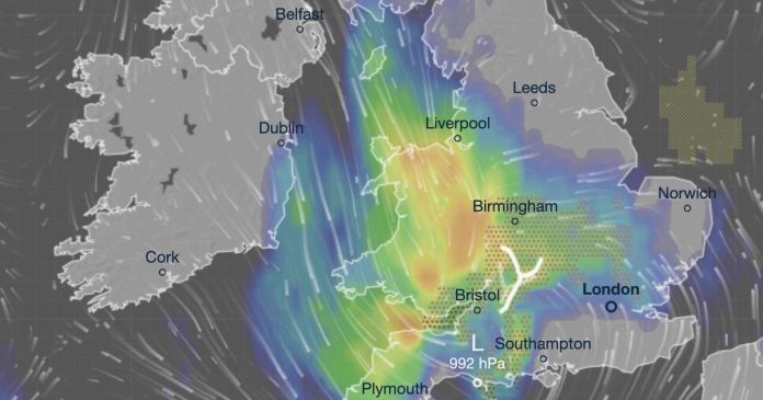
A horror storm spanning hundreds of miles is set to splash thousands with five days worth of rain in a slim, three-hour period this week.
The UK, despite having enjoyed weeks of sun and pleasant warm weather over the last two weeks, now seems set to have its weather fortunes change, with forecasters eyeing an approaching mass of wind and rain. Met Office meteorologists anticipate heavy rain over Tuesday and Wednesday, and have issued a corresponding yellow weather warning predicting Wales and England will be hardest hit by the swirling mass. Drilling down into the expected stats reveals the deluge could deposit up to five days worth of rain in a few short hours.
The maps from Windy.com show the incoming storm will sweep over 212 miles from Weymouth in Dorset to Swadlincote in Derbyshire, crossing Wales in the middle. The forecast suggests up to 11mm of rain will fall in just a few hours in Ludlow which, compared with the April average, comes out to around five days’ worth.
The average April rainfall total is around 72mm over the month’s 30 days which, levels out to approximately 2.4mm per day. Ludlow’s 11mm over just a few hours is five times this, meaning the Shropshire community’s roughly 11,000 people are about to see some of the most significant rain they have seen in 2025 so far.
The dozens of other communities under the yellow weather warning – which activates at 12pm on Tuesday and lasts until the same time the following day – won’t escape lightly, however, as the Met Office anticipates some parts of the country seeing up to 75mm of rain by the time it expires.
The Met Office warns the rain will move westerly, with thunderstorms sparked by the system set to become more “slow-moving” throughout the day. The warning states: “A spell of heavy and persistent rain is expected to move north across western Britain during Tuesday into early Wednesday.
“Whilst there is some uncertainty in where the heaviest rain will fall, 20 to 40mm of rain is expected fairly widely. A few places may see 50 to 75mm of rain during this period: gradually building up in the west following rain on Monday, whilst in parts of the east, falling in shorter periods where heavy showers and thunderstorms become slow-moving.”
The rain seems likely to set off a barmy period for most of the country, with similar conditions following over the next week and into the end of April. From April 19 to 28, the long-range forecast has predicted additional heavy rain and thunderstorms accompanied by strong winds.
The forecast states: “Mixed conditions across the UK at the start of this period. Showers or longer spells of rain are likely across many regions, these heavy at times with a risk of hail and thunder, perhaps accompanied by strong winds. Some drier and brighter interludes are also likely at times, but probably with large amounts of cloud.
“Temperatures will likely be near normal overall. Into the following week, a similar pattern is likely at first with unsettled conditions at times with a risk of some heavy rain or showers. Later in the week settled weather is expected to become more prevalent, with more in the way of dry, sunny weather beginning to develop. Temperatures will probably be around normal or slightly above.”
At Reach and across our entities we and our partners use information collected through cookies and other identifiers from your device to improve experience on our site, analyse how it is used and to show personalised advertising. You can opt out of the sale or sharing of your data, at any time clicking the “Do Not Sell or Share my Data” button at the bottom of the webpage. Please note that your preferences are browser specific. Use of our website and any of our services represents your acceptance of the use of cookies and consent to the practices described in our Privacy Notice and Cookie Notice.


